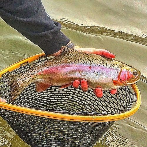
Gold Medal Fishing
There are many places in Delta County to cast your line to try to hook a big one. The Gunnison, Uncompahgre and North Fork Rivers are an angler’s paradise. The more than 300 lakes on Grand Mesa provide ample room to find your own favorite fishing hole. The Gunnison River through the Black Canyon of the Gunnison National Park and Gunnison Gorge National Conservation Area provide over 30 miles of Gold Medal trout fishing. As noted in the book 50 Best Places to Fly Fish Before You Die by Chris Santella, “The Gunnison will not disappoint”.
The June Stonefly Hatch in the Gunnison Gorge attracts anglers from around the world, but fishing is great all year round. Visit The Colorado Parks and Wildlife for special regulations, more fishing information and reports. Check out the My CPW App, the official app of Colorado Parks and Wildlife, for trip planning and recording catches, the myColoradoapp to digitally store your fishing license , and COTREX- the Colorado Trail Explorer App.
Need a Guide – A Lesson?
Black Canyon Anglers – 7904 Shea Rd, Austin
Gunnison River Expeditions – 8949 Pleasure Park Road, Hotchkiss
The Hotchkiss National Fish Hatchery
The Hotchkiss National Fish Hatchery is also a fun stop for young and old. The Hatchery is located about 20 miles east of Delta, Colorado, near the town of Hotchkiss. The hatchery consists of a hatchery building with a small visitor center and tank room, residences, 32 outdoor concrete raceways, 24 nursery tanks, and 6 earthen ponds.
LAKES AND CREEKS OF THE GRAND MESA
Accessed by Hwy 65 and Forest Road 121 from Cedaredge
From Cedaredge travel north on Highway 65 for 16 miles to Forest Road 121. Turn right (east) to begin a drive through a series of Grand Mesa lakes. The following areas are accessible by 2WD passenger vehicles on all weather roads.
Cobbett Lake
Cobbett Lake on your left and Ward Lake. on your right, offer campgrounds. The area is also host to a visitor center, picnic area and restrooms – all easily accessible by passenger vehicle. Restrooms are also handicap accessible in the new visitor center.
Further along. Forest Road 121 passes Thunder Mountain Lodge, Alexander Lake Lodge and Baron Lakes. Several lodges can be found in this area providing food, lodging and a small store.
Eggleston Lake
Eggleston Lake is 2.5 miles along Forest Rd. 121, just beyond Baron Lake. The second largest lake on the Mesa, Eggleston and a complex of smaller lakes nearby create a popular fishing destination as well as a central point for other recreational opportunities such as hiking, four-wheeling and boating. A gravel boat ramp is available at this lake. There are three campgrounds around Eggleston Lake: 1) Crag Crest, which also serves as the parking lot for the Crag Crest trail head 2) Fish Hawk, to the north of Eggleston Lake on Forest Road 121 and 3) Eggleston Lake, halfway up Eggleston Lake (on the far side of the road from the lake).
Kiser Creek
Kiser Creek begins at the south end of Eggleston Lake and flows south to Reed and Kiser Slough reservoirs. Kiser Creek campground is found at the south end of Eggleston Lake and can be reached by Forest Road 123 Kiser Creek holds some good for trout but is more heavily populated by white suckers.
Young’s Creek
Young’s Creek flows from the dam located on the southwest end of Young’s Creek Reservoir No.2. which lies 3.5 miles along Forest Rd. 121 The creek provides some pools that hold brook and cutthroat trout. Young’s Creek Reservoir 2 & 3 are catch and release only.
Trickle Park Reservoir and Weir/Johnson Reservoir
Trickle Park Reservoir and Weir/Johnson Reservoir. Follow Forest Rd. 121 for 8 miles to Forest Rd. 125. Turn right here and go 1/2 mile to Trickle Park Reservoir. To get to Weir and Johnson Reservoir stay on Forest Rd. 121 1.5 miles past the Forest Rd. 125 turnoff and turn right on the Weir and Johnson Road (Forest Rd. 126) for 2.8 miles to the reservoir.
LAKES OF THE GRAND MESA
By Highway 65 and from Cedaredge
Island Lake and Granby Reservoirs
From Cedaredge travel north on Highway 65 for 17 miles to Forest Road 116 headed west (left) off the highway. The largest of the Grand Mesa lakes, Island Lake, offers 3 developed campsites for the physically challenged on the southeast side of the lake. Campsites are joined by 800 feet of paved trail at a 2-4% grade. Picnic tables and a small store are also available in the this area. Island Lake is a popular ice-fishing destination. Follow forest Road 116 half way around Island Lake, look for Forest Road 115 which leads to Granby Reservoirs, a series of reservoirs and natural lakes. The 2.5 to 3 mile road is limited to 4-wheel drives. ATV, foot or horseback. Due to the roughness of the road, it is easier to walk than to drive. There are no developed campsites and trash must be packed out.
Marcott Creek
From Cedaredge, travel north on Highway 65 for 3.5 miles and turn right on Surface Creek Road. Proceed 6 miles to the Grand Mesa National Forest boundary and turn right on Forest Road 127, which is 4WD. Follow this road for 1.5 miles and cross Bonita Creek. Marcott Creek parallels the road for approximately 4.5 miles.
Crawford Reservoir
From Crawford. travel I mile south on Highway 92 to the easily accessed Crawford Reservoir. The reservoir is a State Park. so there are many places to access the water. Though Crawford Reservoir is stocked with rainbow trout from the Hotchkiss National Fish Hatchery. it is now best known as an excellent yellow perch fishery. Largemouth bass and channel catfish are caught here as well – some catfish weighing 20 pounds or more! The reservoir also contains crappie and northern pike.
Morrow Point Reservoir
From Crawford. travel south on Highway 92 for 22 miles to Hermit’s Rest. A well marked trail begins here with camping and restrooms available at the bottom of the trail. Allow at least one hour to hike the trail.
Crystal Creek – Dyer Creek
From Crawford. travel south on Highway 92 for 12 miles to the Forest Service access road to Black Mesa. Follow this road for 4.5 miles to the Forest Service boundary where it becomes Forest Rd 713. Within the next 2 miles. several pull-offs can be found along Crystal Creek. Fishing for brookies is good, especially in the beaver ponds
Just past the Forest Service boundary take the first left (at the sign) and drive up the 4-wheel drive road to private land Park here and walk around the private land 1/2 mile to the Dyer Creek. There are several forks with several miles of brook trout fishing.
Little Coal Creek
From the Crawford Post Office. head east and follow E-50 Drive until the pavement ends at a T-intersection. Continue north II2 mile to the next T-intersection. turn east onto F Road and travel approximately I mile taking the next available left turn. Continue around past Needle Rock on the north and continue up Forest Rd 835 (4WD) for 2 miles past Needle Rock to the Forest Service trail head. From there. follow Trail 890 north for 1.5 miles to Little Coal Creek for some excellent beaver pond fishing. Expect to catch brookies and cutthroats here.
Smith Fork of the Gunnison
From Crawford, turn east at the post office and follow the road. E-50 Drive, past Needle Rock and Saddle Mountain Guest Ranch to the Smith Fork Campground. Public fishing is allowed at the bridge and with permission below Saddle Mountain Guest Ranch since that section of river is stocked. Drive east past the cattle guard to reach Forest Service and upstream access. Another 1.25 miles east you will come to a fork in the road. Take the right fork, drive around the private land and follow the next left to the South Smith Fork Trail head (Trail 860). From here, you can walk approximately 100 yards to the South Smith Fork which is periodically stocked with fingerling cutthroat trout.
Hubbard Creeks: West. Mid and Main
From Paonia, head north on County Road 4010 (Stevens Gulch Road). As you cross the USFS boundary (7 miles), the road turns into Forest Road 701. Pass under the high tension power lines twice and travel 2.5 miles further. West and Mid-Hubbard (Creeks can he reached by walking west from the road up a small reclaimed road for 1/2 mile. Both creeks are difficult to find. but well worth the search Back on Forest Rd 701, travel north another mile. you will enter Hubbard Park. Main Hubbard Creek runs through the middle of the park. You can fish up or down the creek. Please pay attention to and stay off the private lands in this area.
Roeber Reservoir
From Paonia, go south on 4100 Road. Follow 4100 to 4050 Road and continue south. As the road turns to the east. it becomes L30 Road. This road travels through the McCluskey State Wildlife Area which is closed to all human activity during the winter months. Follow L30 Road into the forest. The road number changes to Forest Road 834. Follow Forest Road 834 (4WD) to the very top of the hill and follow the North Fork. You will need to walk down to Roeber Reservoir which can be seen below the road.
COW Creek, Dyke Creek, Overland Reservoir and Crater Lake
From Paonia, travel north of Stevens Gulch Road (County Road 4010) and cross USFS boundary where the road number changes to Forest Road 701. Fifteen miles north, look for an intersection with Forest Road 705. Cow Creek lies just south of this intersection and Dyke Creek is the first creek north of the intersection along Forest Road 701. Turning west on Forest Road 705 and traveling for approximately 3 miles, will lead you to Overland Reservoir. You can park along any of the graveled roads in the area. To reach Upper Cow Creek and Crater Lake, park on the north side of Overland Reservoir and follow the trail around the lake to the west. Approximately 3/4 of a mile, the trail will open up into a large park. Cow Creek runs through the middle of the park. To get to Crater Lake. follow the trail on the north side of the park for approximately 1.5 mile through one set of trees and to a second set of trees where you will see a trail marker post at the crest of a hill. From this post. walk directly south. crossing the park and cross Cow Creek. A second post can be seen on the south side of the park. Follow the trail from this post south into the forest and you will find Crater Lake within 1/4 mile.
Clear Fork of Muddy Creek
From Paonia. head northeast on Highway 133 for 26 miles and turn left (west) at the Collbran turnoff. Follow this road (turns into Forest Rd 265) approximately 6 miles to Forest Road 844. Turn right and follow Forest Rd 844 to its end, approximately 3 miles. The creek you cross is the Clear Fork of the Muddy. Walk at least 1/2 mile up the creek before you start to fish.
Buck Creek Basin Lakes
From Paonia travel northeast on Highway 133 for approximately 33 miles to the crest of McClure Pass. Forest Road 898 and Trail 820 both begin at the summit of McClure Pass and head south. The road will cross the trail twice, the second time at about 3 miles, From here, you have to start on the trail. Walk south on the trail f61flPProxiimately 4 miles, then climb southeast up to the Buck Creek Basin. You will see the lakes. The access is very rough and trails are hard to find.
Accessed from Kebler Pass Road and Forest Road 709
Coal Creek, North and South Gunnison Lakes, Sheep Lake
From Paonia, take Highway 133 northeast for 16 miles to Kebler Pass Road. Follow Kebler Pass Road about 2 miles to Forest Road 709 which heads right (south). Coal Creek parallels Forest Rd 709 to the road’s end (approximately 10 miles).
Follow Forest Rd 709 approximately 6 miles and park on public forest land south of the private property. Cascade Creek flows into Coal Creek from the west here. Follow Cascade Creek for 3.5 to 4 miles west to North Gunnison Lake. Travel approximately 1 mile southeast to South Gunnison Lake. Access is very rough. Trails are present, but hard to find.
Follow Forest Rd 709 to its end (10 miles) to the Trail 850 Trail head. Take Trail 850 about 6 miles southeast to the base of the mountains where several trails come together. Sheep Lake lies approx. 1 mile southeast of this point No camping is allowed at Sheep Lake. A Forest map is recommended as there are several trails in this area.
North and Middle Anthracite Creeks, Williams Creek Lake, Tomahawk Reservoir, and North Deep Creek Lake; Ruby Anthracite and Cliff Creeks; Lost Lake Slough, Lost Lake and Dollar Lake
From Paonia, take Highway 133 northeast for 16 miles to Kebler Pass Road. Follow Kebler Pass Road approximately 5 miles to Erickson Springs Campground. From the campground, follow the Dark Canyon Trail east approx. 5 miles to a point at which the trail divides into northern and southern directions. Trails follow along North and Middle Anthracite Creeks. You can also take Forest Road 759 (4WD) from the campground approximately 2 miles to the Trail 820 trail head. Trail 820 heads north to Williams Creek Lake and Tomahawk Reservoir. An ATV can be used on this trail. About 1/2 mile from the trail head Trail 824 splits from Trail 820 and climbs northeast for about 3 miles to the Deep Creek Basin and North Deep Creek Lake.
Ruby Anthracite Creek can be reached by continuing on Kebler Pass Road II miles past Erickson Springs Campground to Horse Ranch Park. The creek parallels the road here. Take Trail 840 south from Horse Ranch Park over Beckwith Pass for approximately 5 miles to Cliff Creek.
Follow Kebler Pass Road from Highway 133 for 12 miles to Forest Road 706. Go south approximately 2.5 miles on this road which ends at Lost Lake Slough. A 1 mile loop trail will take you to Lost Lake and Dollar Lake.