Formed by three rivers, surrounded by four cañons, all under the watchful eye of mountain peaks and a blanket of stars . . .
Here is the scoop on the places to go find yourself. No matter what your skill level or desire to breath hard, we have something that will challenge and delight you.
 |
 |
 |
HIKES – TOP TO BOTTOM
Crag Crest National Recreation Trail
The Crag Crest Trail in the Grand Mesa National Forest, Colorado, was designated as a National Recreation Trail by John McGuire of the US Forest Service on March 14, 1978.
This 2-loop trail feels like true wilderness, with a view on the world. Choose your hike length and go. This trail is at high altitude in Colorado, so plan to hike early and be done before 3:00 in the afternoon to avoid storms. There are two lengths to fit your plans. The Crest portion is 6.5 miles and rises gradually to the Crest from either of the two trail heads. There are steep drops on portions of the trail. The Loop portion is 3.4 miles and offers an option to suite your day. For more information visit Grand Mesa Uncompahgre National Forest – Crag Crest Trail. Here you will find a downloadable map and guide.
Jumbo Mountain
One of the most popular hikes in the Paonia area, Jumbo Mountain Trail is a 7.8 mi loop trail. Reaching an elevation of 5,807 with a climb of nearly 1,200 feet, this is a great workout, the view will reward you at the summit. It’s great for a challenging workout and is just as enjoyable for casual day hikers traveling at a leisurely pace. Plan a morning of hiking, a farm fresh lunch and an afternoon enjoying some of the area’s craft beverages – there are eight locations offering anything from cold pressed organic juices to wines and pommeau. For local maps and tips for the day visit Cirque Cyclery to get started.
North Rim of the Black Canyon National Park
Make a day trip to the Black Canyon of the Gunnison National Park North Rim. The Black Canyon of the Gunnison was formed slowly by the action of water and rock scouring down through hard Proterozoic crystalline rock. No other canyon in North America combines the narrow opening, sheer walls, and startling depths offered by the Black Canyon of the Gunnison.
The North Rim via Crawford has fewer crowds, spectacular views and unprecedented heights. The sheerness and depths of this canyon once inspired president Roosevelt to consider this one of the state’s most unusual features.
People travel in from around the world to climb the walls of the Black Canyon. There are easy, moderate and difficult trails for those who do not wish to scale the walls. Special permits and skills are required to climb the walls. Others can just observe these climbers from a safe distance and enjoy the beauty of the canyon.
For more information, visit the official National Park Service Black Canyon of the Gunnison web site.
 |
 |
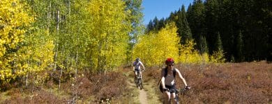 |
PEDAL POWER
Sidewinder Trail
Sidewinder provides almost 20 miles of technical desert single track and numerous slick rock sections. The access roads allow you to bite off only as much as you want. There are a few fast/flowy sections and a lot of technical moves to keep you on your toes. The trail is a blast, but don’t forget to stop once in a while to enjoy the amazing views. Need a Map?
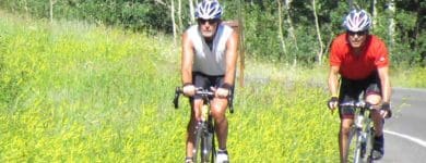
Escalante Rim Tour
This fun ride is generally easy to moderate for most. Enjoy some adobe badlands, an historic bank robber trail and the art in stone. You can choose the length of your ride and the features you wish to see. This ride can be enjoyed almost year ’round. The elevation is about 5,300 ft with little changes in the ride – that’s not to say it’s flat! Need a Map?
The Delta Drop
It’s not your leisurely ride. The views might make you think you are on a Sunday Drive, but pay attention to the trail. It’s fun and can be fast. Starting on top of the Grand Mesa at around 10,000 ft elevation and dropping into Delta at around 6,000 ft elevation, you understand where the name comes from.
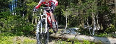
Now onto Jumbo Mountain outside of Paonia, for the fun of it.
After 1-2 miles of fairly smooth riding, it’s a steady workout with some switchbacks to navigate. There is some hike-a-bike terrain to consider on the way to the top, but you can do it. Then you get a chance to relax and be rewarded with great views for your efforts. Bike like a local, drink like a local, is one motto in Paonia. Link to More
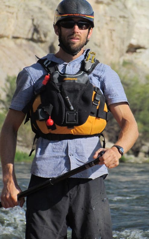 |
GET WETGold Medal Waters of the Gunnison River Some of the most pristine fishing in North America can be found right here. The Gunnison River has guides that offer trips anglers dream of and for those with less in their pockets that same river has access points that don’t require a guide and that you can walk right up to. It’s a river for everyone, but only the best will lure in that “lunker photo op.” The Gunnison River is also a favorite for boating, canoeing and SUP use. Need a guide? try Black Canyon Anglers or Gunnison River Expeditions Grand Mesa It’s called the Grand Mesa for very good reason. It’s 4,000 acres of of outdoor playground with over 300 lakes and a few streams. These waters are pure and fresh. The product of rain, snow melt and natural springs, there is plenty of water. Fish like water, so there are plenty of fish. Stop in at one of the lodges, they usually are dialed in for the best fishing in the area. Many lakes are right along the road, some are a short hike and for those with ambitions of solitude and great fishing you can hike into lakes a bit further out. Stand Up Paddle Boarding You’ll see a little bit of everything on the waters around Delta County. Yes, even the newest watersport of Stand Up Paddleboarding. The rivers, the State Parks, lakes and almost anything that will float the board. Guides are available with Western Slope SUP.
|
SNOWAY TO GO
Grand Mesa Nordic Trails
Cross-country skiers have been enjoying skiing on the world’s largest flat-top mountain for decades. At the Grand Mesa, located just an hour from downtown Grand Junction, the ski season begins as early as Halloween and can last well into April.
| “I’ve lived all over the world, skied a lot in Europe, ski raced in Europe and Canada all over North America, and we have the best skiing in the world,” said Christie Aschwanden, GMNC |
The Grand Mesa Nordic Council Grooms many trails, while some are left for the skiers to break trails on their own. Visit their site for tips on snowshoeing and dog trails as well. Grand Mesa Nordic Council, oh, and they have a great map too.
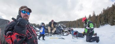
Grand Mesa Snowmobile Trails
Grand Mesa is so big that there is room for all. Over the years our locals have learned to play well in the snow together. Our skiers stay on one side of Hwy 65 (the Grand Mesa National Scenic and Historic Byway) and the skiers and snowshoers keep on the other. This means the speeds and sounds of the sleds are less noticed and the solitude of the trails for the skiers is enjoyed.
The Powderhorn to Sunlight trail is groomed and marked with green reflectors and provides access to approximately 180 miles of groomed and ungroomed trails. There are numerous access points, which makes this trail perfect for the experienced snowmobiler as well as the newcomer. Enjoy the spectacular views of snow-covered mountains as you explore the trails. The trail begins off of Forest Service Rd 121 just past the Grand Mesa Visitor Center. Lodging can be found at Mesa Lakes Lodge, Alexander Lake Lodge, Thunder Mountain Lodge, Powderhorn Resort and the Grand Mesa Lodge.
The Sunlight to Powderhorn Trail inlcludes routes from Sunlight Ski Area near Glenwood Springs on the White River National Forest and to the west end of the Grand Mesa south of the Powderhorn Ski Area on the Grand Mesa National Forest.